Monk’s Trail to Wat Pha Lat
A forest pilgrimage path leading toward Wat Pha Lat, for visitors prepared for uneven terrain.
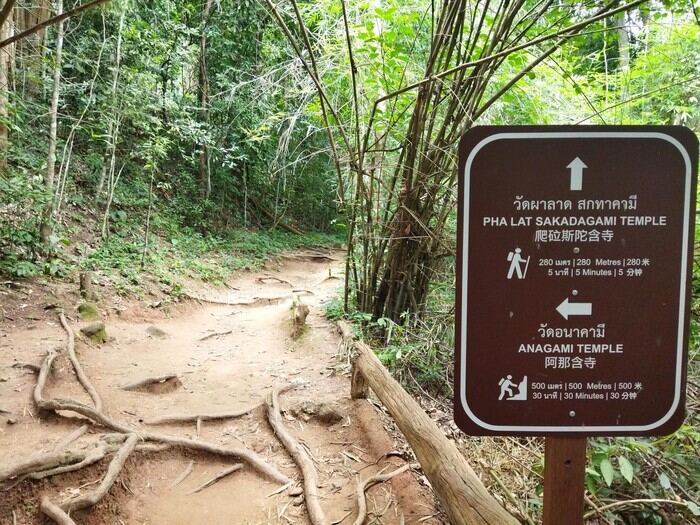
Photo source: Monk’s Trail sign — Wikiloc
About the managing body
Applicable national park and temple authorities
The named operator or relevant local authority oversees visitor arrangements, site use or services. Follow current entrance notices, temple etiquette and conservation rules as applicable.
Basic information
- Address
- Monk’s Trail trailhead, Suthep, Mueang Chiang Mai, Chiang Mai, Thailand
- Visiting conditions
- National park access rules, trail permits and fees may change; verify at the trailhead.
Why visit
The trail’s meaning lies in the transition from forest footpath to temple space. Trail markers, exposed roots and the first religious structures are more informative than treating the hike as a shortcut.
Opening hours · Admission and costs
Verify the entrance notice, opening window, admission or parking fee on the day of travel. Separate facilities may charge independently; an unverified fixed price is intentionally omitted.
Getting there · Suggested route
Locate the dedicated Monk’s Trail trailhead rather than beginning on the busy mountain road; check park rules, weather and a return plan before walking.
For mountain roads, confirm return transport and weather. Use designated walking trails rather than traffic lanes.
History, landscape and experiences
The path is associated with the mountain’s Buddhist pilgrimage landscape. It differs from the paved road Kruba Srivichai helped build and should not be confused with the road shoulder.
What to notice
Notice tree cover, changing ground surfaces and the transition into a living temple setting. Stay on designated paths and respect monks.
Suggested visit in three steps
- 1Locate the correct entrance or pickup point — Locate the dedicated Monk’s Trail trailhead rather than beginning on the busy mountain road; check park rules, weather and a return plan before walking.
- 2Explore the main features respectfully — Use shaded forest views or temple approaches from marked paths. Do not obstruct walkers or religious activity.
- 3Continue to another verified nearby stop
Before you go
Carry drinking water and sun protection, expect slippery ground during rainy weather, dress respectfully at temples, and avoid unsafe roadside stops.
Photography tips
Use shaded forest views or temple approaches from marked paths. Do not obstruct walkers or religious activity.
Where to stay
For a short visit, Chiang Mai city or the university/Nimman area is a practical base. For mountain excursions, factor winding roads and return transport into your lodging choice.
Visitor reviews
Ratings vary by listing and date. Open the exact place on Google Maps for the latest visitor reviews; no unverified score is reproduced here.
Google Maps ↗Frequently asked question
Is this a paved stroll? No. Uneven surfaces, rain and access controls make it a hiking decision.
Address and navigation
Monk’s Trail trailhead, Suthep, Mueang Chiang Mai, Chiang Mai, Thailand
Open dedicated Google Maps location ↗Source and local checks
General Chiang Mai travel context is informed by Tourism Authority of Thailand resources. Where available, a dedicated destination reference is linked below; confirm visiting conditions locally.
Tourism Authority of Thailand ↗